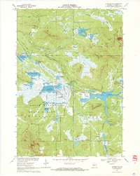
1970 Map of Hatfield SE
USGS Topo · Published 1972About this map
Black River State Forest dominates this Central Wisconsin landscape, where an extensive network of managed wetlands and flowages defines the local geography. In the early 1970s, the region was heavily shaped by water management and cranberry production, evidenced by numerous Cranberry Bogs and specialized water bodies like Seventeen Flowage and White Tail Flowage. The terrain is punctuated by distinctive topographic rises such as Saddle Mound and Wildcat Mound, which stand out against the low-lying marshes. Transportation history is visible through the Old Railroad Grade and Old Road segments that crisscross the Purreburg Marsh and Dresher Marsh. Significant hydraulic engineering is present throughout, including the Battle Point Flowage and Black Duck Flowage, reflecting a landscape optimized for conservation, forestry, and specialized agriculture.
Find a feature on this map
53 named features on this map. Tap any name to fly to it.
Don’t see what you’re looking for? This feature index may not catch every label — zoom into the map to look around manually.
Map Details
Editions of this 1970 Hatfield SE Map
2 editions found
Other maps of this area

1947 · Millston
USGS Topo · 1:62,500

1949 · Millston
USGS Topo · 1:62,500

1953 · Eau Claire
USGS Topo · 1:250,000

1957 · City Point
USGS Topo · 1:48,000

1958 · Eau Claire
USGS Topo · 1:250,000

1958 · Hatfield
USGS Topo · 1:48,000

1958 · Wyeville
USGS Topo · 1:48,000

1964 · Eau Claire
USGS Topo · 1:250,000
1970 · Hatfield SW
USGS Topo · 1:24,000

1970 · Spaulding
USGS Topo · 1:24,000