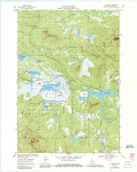
1970 Map of Hatfield SE
USGS Topo · Published 1985About this map
Black River State Forest dominates this Central Wisconsin landscape, where the management of water defines the local geography. The map documents an extensive network of managed wetlands and reservoirs, including Potter Flowage, White Tail Flowage, and Black Duck Flowage. These water bodies are interspersed with numerous Cranberry Bogs and marshes like Johnson Marsh, illustrating the region's historical reliance on cranberry production. Rising above the lowlands are prominent landmarks such as Wildcat Mound and Saddle Mound, the latter featuring a Lookout Tower.
Find a feature on this map
50 named features on this map. Tap any name to fly to it.
Don’t see what you’re looking for? This feature index may not catch every label — zoom into the map to look around manually.
Map Details
Editions of this 1970 Hatfield SE Map
2 editions found
Other maps of this area

1947 · Millston
USGS Topo · 1:62,500

1949 · Millston
USGS Topo · 1:62,500

1953 · Eau Claire
USGS Topo · 1:250,000

1957 · City Point
USGS Topo · 1:48,000

1958 · Eau Claire
USGS Topo · 1:250,000

1958 · Hatfield
USGS Topo · 1:48,000

1958 · Wyeville
USGS Topo · 1:48,000

1964 · Eau Claire
USGS Topo · 1:250,000
1970 · Hatfield SW
USGS Topo · 1:24,000

1970 · Spaulding
USGS Topo · 1:24,000