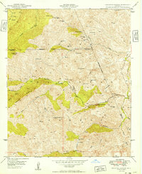
1949 Map of Haunted Canyon
USGS Topo · Published 1949About this map
Miles Ranch and Tony Ranch sit within a high-elevation landscape where the Tonto National Forest and Crook National Forest meet. This 1949 edition, based on 1945 aerial photography, documents the complex watershed system feeding into Pinto Creek and the West Fork Pinto Creek. The terrain is defined by dramatic landforms such as Pinto Peak and the Sawtooth Ridge, with the southern portion of the sheet marked by the Salt River Base Line. Numerous springs are recorded throughout the canyons, including the uniquely named Mowing Machine Spr, Bootlegger Spr, and Fifty Dollar Spr. These water sources were vital for the high-country ranching operations and are mapped alongside local landmarks like Government Hill and J K Mountain.
Find a feature on this map
45 named features on this map. Tap any name to fly to it.
Don’t see what you’re looking for? This feature index may not catch every label — zoom into the map to look around manually.
Map Details
Editions of this 1949 Haunted Canyon Map
2 editions found
Other maps of this area

1900 · Florence
USGS Topo · 1:125,000

1901 · Globe
USGS Topo · 1:62,500

1902 · Globe
USGS Topo · 1:62,500

1902 · Florence
USGS Topo · 1:125,000

1907 · Roosevelt
USGS Topo · 1:125,000

1909 · Four Peaks
USGS Topo · 1:125,000

1912 · Roosevelt
USGS Topo · 1:125,000

1922 · Chrysotile
USGS Topo · 1:125,000

1945 · Inspiration
USGS Topo · 1:24,000

1947 · Inspiration
USGS Topo · 1:24,000