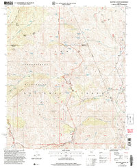
2004 Map of Haunted Canyon
USGS Topo · Published 2007About this map
Miles Ranch and Tony Ranch anchor this landscape of the eastern Superstition Mountains, where the drainage of Haunted Canyon meets the high ridges of the Tonto National Forest. The topography is defined by the sharp elevations of Pinto Peak and Grizzly Mountain, separated by deep cuts like Powers Gulch and the West Fork Pinto Creek. This area of the Superstition Wilderness shows a territory utilized for remote ranching and prospecting, evidenced by several Prospect labels and numerous named water sources. Features like Mowing Machine Spring, Fifty Dollar Spring, and Bootlegger Spring suggest the colorful local history and the critical importance of water in this arid environment. The network of the Campaign Trail and Ranger Trail provide the primary access through the Sawtooth Ridge and Bull Basin areas.
Find a feature on this map
80 named features on this map. Tap any name to fly to it.
Don’t see what you’re looking for? This feature index may not catch every label — zoom into the map to look around manually.
Map Details
Editions of this 2004 Haunted Canyon Map
This is the sole edition of this map. No revisions or reprints were ever made.
Other maps of this area

1900 · Florence
USGS Topo · 1:125,000

1901 · Globe
USGS Topo · 1:62,500

1902 · Globe
USGS Topo · 1:62,500

1902 · Florence
USGS Topo · 1:125,000

1907 · Roosevelt
USGS Topo · 1:125,000

1909 · Four Peaks
USGS Topo · 1:125,000

1912 · Roosevelt
USGS Topo · 1:125,000

1922 · Chrysotile
USGS Topo · 1:125,000

1945 · Inspiration
USGS Topo · 1:24,000

1947 · Inspiration
USGS Topo · 1:24,000