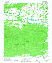
1966 Map of Havana
USGS Topo · Published 1967About this map
Havana serves as the primary hub of this mid-1960s landscape, situated along the Chicago Rock Island and Pacific railroad line. The settlement pattern follows the fertile corridor of the Petit Jean River, which meanders eastward through a valley defined by the Ouachita National Forest to the south. North of the river, small clusters of development like Marvinville and several family-named burial grounds, including Underwood Cem and Walker Cem, indicate a long-standing agricultural community.
Find a feature on this map
31 named features on this map. Tap any name to fly to it.
Don’t see what you’re looking for? This feature index may not catch every label — zoom into the map to look around manually.
Map Details
Editions of this 1966 Havana Map
This is the sole edition of this map. No revisions or reprints were ever made.
Other maps of this area

1879 · Mountain Home
USGS Topo · 1:62,500

1887 · Magazine Mountain #4
USGS Topo · 1:62,500

1887 · Magazine Mountain
USGS Topo · 1:62,500

1888 · Dardanelle #3
USGS Topo · 1:62,500

1890 · Magazine Mountain
USGS Topo · 1:125,000

1890 · Mount Ida
USGS Topo · 1:125,000

1890 · Hot Springs
USGS Topo · 1:125,000

1890 · Dardanelle
USGS Topo · 1:125,000

1894 · Hot Springs
USGS Topo · 1:125,000

1955 · Little Rock
USGS Topo · 1:250,000