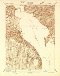
1938 Map of Haverstraw
USGS Topo · Published 1938About this map
Haverstraw and Croton on Hudson anchor this pre-war survey of the lower Hudson Valley, where the river widens into the Haverstraw Bay. The landscape is defined by the industrial and transport infrastructure of the late 1930s, featuring the prominent West Shore RR and New York Central Railroad lines hugging the shorelines. On the western bank, the Traprock Quarry and several smaller quarries near Tompkins Cove point to the region's active mineral extraction, while institutions like the New York Reconstruction Home near Garnerville and the St Peters Cem provide deep genealogical context. The transition from industrial waterfront to protected land is already evident at Stony Point State Park and Hook Mountain Park. Navigation and aviation history are preserved through the Rockland Lighthouse and Christie Airport, reflecting a river corridor in the midst of mid-century modernization.
Find a feature on this map
73 named features on this map. Tap any name to fly to it.
Don’t see what you’re looking for? This feature index may not catch every label — zoom into the map to look around manually.
Map Details
Editions of this 1938 Haverstraw Map
This is the sole edition of this map. No revisions or reprints were ever made.
Other maps of this area

1891 · Ramapo
USGS Topo · 1:62,500

1892 · West Point
USGS Topo · 1:62,500

1892 · Tarrytown
USGS Topo · 1:62,500

1893 · Tarrytown
USGS Topo · 1:62,500

1893 · Ramapo
USGS Topo · 1:62,500

1894 · West Point
USGS Topo · 1:62,500

1899 · West Point
USGS Topo · 1:62,500

1901 · West Point
USGS Topo · 1:62,500

1902 · Tarrytown
USGS Topo · 1:62,500

1902 · Schunemunk
USGS Topo · 1:62,500