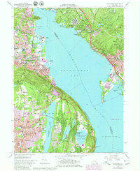
1979 Map of Haverstraw
USGS Topo · Published 1979About this map
The Hudson River dominates this mid-1970s landscape, widening into Haverstraw Bay between the industrializing western shore and the wooded ridges of Cortlandt to the east. Urban expansion, highlighted in purple, is visible around Haverstraw and Croton-on-Hudson, revealing the post-war growth of residential neighborhoods and institutional sites. On the western bank, significant facilities like the State Rehabilitation Hospital and the F D Roosevelt VA Hospital occupy prominent positions, while the Stony Point Lighthouse stands as a maritime landmark. Inland, the map captures the transition from village centers to suburban tracts near New City, alongside several recreational and natural zones such as High Tor State Park and Rockland Lake State Park. Water management is evident through the presence of De Forest Lake and the Hackensack River corridor, reflecting the region's infrastructure needs during this period of development.
Find a feature on this map
98 named features on this map. Tap any name to fly to it.
Don’t see what you’re looking for? This feature index may not catch every label — zoom into the map to look around manually.
Map Details
Editions of this 1979 Haverstraw Map
This is the sole edition of this map. No revisions or reprints were ever made.
Other maps of this area

1891 · Ramapo
USGS Topo · 1:62,500

1892 · West Point
USGS Topo · 1:62,500

1892 · Tarrytown
USGS Topo · 1:62,500

1893 · Tarrytown
USGS Topo · 1:62,500

1893 · Ramapo
USGS Topo · 1:62,500

1894 · West Point
USGS Topo · 1:62,500

1899 · West Point
USGS Topo · 1:62,500

1901 · West Point
USGS Topo · 1:62,500

1902 · Tarrytown
USGS Topo · 1:62,500

1902 · Schunemunk
USGS Topo · 1:62,500