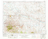
1953 Map of Havre
USGS Topo · Published 1976About this map
The Bearpaw Mountains dominate the southern landscape of this North Central Montana region, rising sharply above the winding Milk River valley. This 1974 revision of the mid-century survey documents a vast agricultural and tribal landscape, encompassing the Fort Belknap Indian Reservation and Rocky Boys Indian Reservation. The Burlington Northern railroad serves as the primary artery for the High Line settlements of Havre, Chinook, and Harlem. Near Havre, specialized infrastructure like the Experimental Station and a nearby Radar station sit alongside traditional ranching and petroleum interests, including a northern Oil Field. Conservation is a prominent theme, with significant acreage dedicated to the Lake Thibadeau National Wildlife Refuge and Creedman Coulee National Wildlife Refuge near the border with Saskatchewan.
Find a feature on this map
121 named features on this map. Tap any name to fly to it.
Don’t see what you’re looking for? This feature index may not catch every label — zoom into the map to look around manually.
Map Details
Editions of this 1953 Havre Map
3 editions found

Other maps of this area

1890 · Fort Benton
USGS Topo · 1:250,000

1892 · Fort Benton
USGS Topo · 1:250,000

1897 · Fort Benton
USGS Topo · 1:250,000

1903 · Wayne Creek
USGS Topo · 1:62,500

1904 · Yantic
USGS Topo · 1:62,500

1904 · Chinook
USGS Topo · 1:62,500

1904 · Havre
USGS Topo · 1:62,500

1904 · Assinniboine
USGS Topo · 1:62,500

1904 · Boxelder
USGS Topo · 1:62,500

1905 · Wayne Creek
USGS Topo · 1:62,500