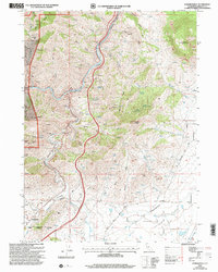
2001 Map of Hawkinsville
USGS Topo · Published 2004About this map
Hawkinsville and Riverview anchor the southwestern corridor of this Siskiyou County landscape, situated near the Yreka Corporate Boundary. The terrain is defined by the significant confluence where the Shasta River meets the Klamath River, carving through deep canyons and gulches. Evidence of the region’s mineral history is scattered across the slopes, including the Negro Boy Mine, High Grade Mine, Union Mine, and the Gold Leaf Mine near Badger Mtn.
Find a feature on this map
38 named features on this map. Tap any name to fly to it.
Don’t see what you’re looking for? This feature index may not catch every label — zoom into the map to look around manually.
Map Details
Editions of this 2001 Hawkinsville Map
This is the sole edition of this map. No revisions or reprints were ever made.
Other maps of this area

1886 · Shasta
USGS Topo · 1:250,000

1894 · Shasta
USGS Topo · 1:250,000

1922 · Shasta Valley Sheet No 4
USGS Topo · 1:24,000

1922 · Shasta Valley Sheet No 3
USGS Topo · 1:24,000

1922 · Shasta Valley Sheet No 14
USGS Topo · 1:24,000

1922 · Shasta Valley Sheet No 5
USGS Topo · 1:24,000

1932 · Yreka
USGS Topo · 1:96,000

1934 · Macdoel
USGS Topo · 1:96,000

1939 · Yreka
USGS Topo · 1:125,000

1941 · Macdoel
USGS Topo · 1:125,000