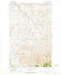
1962 Map of Hawley Hill
USGS Topo · Published 1964About this map
The international boundary between the United States and Canada defines the northern edge of this landscape, where Liberty County, Montana, meets Alberta's Medicine Hat District. In the early 1960s, the high plains here supported a mix of energy extraction and ranching operations. The Whitlash Gas and Oil Field dominates the central terrain with numerous oil wells and a gas well connected by a dedicated pipeline. Despite the industrial presence, traditional family-named ranching properties remain the primary markers of settlement across the coulees and ridges. From Bingham Ranch in the northeast to the Old Hawley Ranch and Thompson Ranch in the south, these holdings followed water sources like Whitlash Creek and Keller Creek. The presence of the Bear Gulch Sch near the center of the sheet indicates a small, localized community center serving the families working this isolated borderland.
Find a feature on this map
34 named features on this map. Tap any name to fly to it.
Don’t see what you’re looking for? This feature index may not catch every label — zoom into the map to look around manually.
Map Details
Editions of this 1962 Hawley Hill Map
This is the sole edition of this map. No revisions or reprints were ever made.
Other maps of this area

1954 · Shelby
USGS Topo · 1:250,000

1958 · Shelby
USGS Topo · 1:250,000
1962 · Bingham Lake
USGS Topo · 1:24,000

1962 · Whitlash
USGS Topo · 1:24,000

1962 · Haystack Butte
USGS Topo · 1:24,000

1962 · Mount Lebanon
USGS Topo · 1:24,000

1962 · Grassy Butte
USGS Topo · 1:24,000

1984 · Sweet Grass Hills
USGS Topo · 1:100,000
2011 · Hawley Hill
USGS Topo · 1:24,000
2011 · Bingham Lake
USGS Topo · 1:24,000