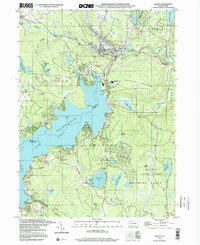
1997 Map of Hawley
USGS Topo · Published 2000About this map
Lake Wallenpaupack dominates the landscape of Wayne and Pike Counties, serving as the central hub for local recreation and community infrastructure during the late twentieth century. Along the northern shores, the settlement of Hawley sits at the confluence of the Lackawaxen River and Middle Brook, while Wilsonville and West Hawley mark the industrial and residential edges of the borough. The map reveals a transition from the structured street grids of these towns to the winding forest roads of State Game Lands No 183 and Delaware State Forest. Genealogists will find notable burial sites and historic congregations including Paupack Cem and the Paupack Ch. To the south, the terrain rises toward Buckhorn Mountain, interspersed with smaller water bodies like Fairview Lake and Lake Wenonah, reflecting the region's character as a dense network of mountain lakes and timberland.
Find a feature on this map
66 named features on this map. Tap any name to fly to it.
Don’t see what you’re looking for? This feature index may not catch every label — zoom into the map to look around manually.
Map Details
Editions of this 1997 Hawley Map
This is the sole edition of this map. No revisions or reprints were ever made.
Other maps of this area

1892 · Honesdale
USGS Topo · 1:62,500

1920 · Damascus
USGS Topo · 1:62,500

1923 · Damascus
USGS Topo · 1:62,500

1928 · Ariel
USGS Topo · 1:62,500

1932 · Ariel
USGS Topo · 1:62,500

1935 · Hawley
USGS Topo · 1:62,500

1938 · Hawley
USGS Topo · 1:62,500

1943 · Honesdale
USGS Topo · 1:125,000

1944 · Damascus
USGS Topo · 1:62,500

1946 · Honesdale
USGS Topo · 1:24,000