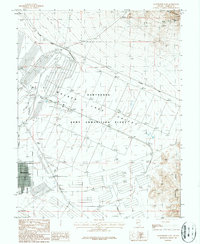
1987 Map of Hawthorne East
USGS Topo · Published 1987About this map
The Hawthorne Army Ammunition Plant dominates the arid landscape of Walker Lake Valley in this late 1980s survey. The vast military installation is defined by a rigorous grid of roads and bunkers, stretching south from the shores of Walker Lake toward the Garfield Hills. This high-desert region is a study in logistics and industry, where the Southern Pacific railroad passes through Thorne to serve the depot and the nearby town of Hawthorne. Mineral extraction is evident in the northern reaches, where the Gillis Range contains workings such as the Dover Mine and Green Talc Mine. The presence of a Municipal Airport and a dedicated Athletic Field reflects the civilian infrastructure supporting this critical defense hub during the final years of the Cold War era.
Find a feature on this map
17 named features on this map. Tap any name to fly to it.
Don’t see what you’re looking for? This feature index may not catch every label — zoom into the map to look around manually.
Map Details
Editions of this 1987 Hawthorne East Map
3 editions found
Other maps of this area

1909 · Hawthorne
USGS Topo · 1:250,000

1911 · Hawthorne
USGS Topo · 1:250,000

1915 · Hawthorne
USGS Topo · 1:250,000

1948 · Walker Lake
USGS Topo · 1:250,000

1955 · Powell Mtn
USGS Topo · 1:62,500

1955 · Hawthorne
USGS Topo · 1:62,500

1957 · Walker Lake
USGS Topo · 1:250,000

1962 · Walker Lake
USGS Topo · 1:250,000

1964 · Walker Lake
USGS Topo · 1:250,000

1967 · Pamlico
USGS Topo · 1:24,000