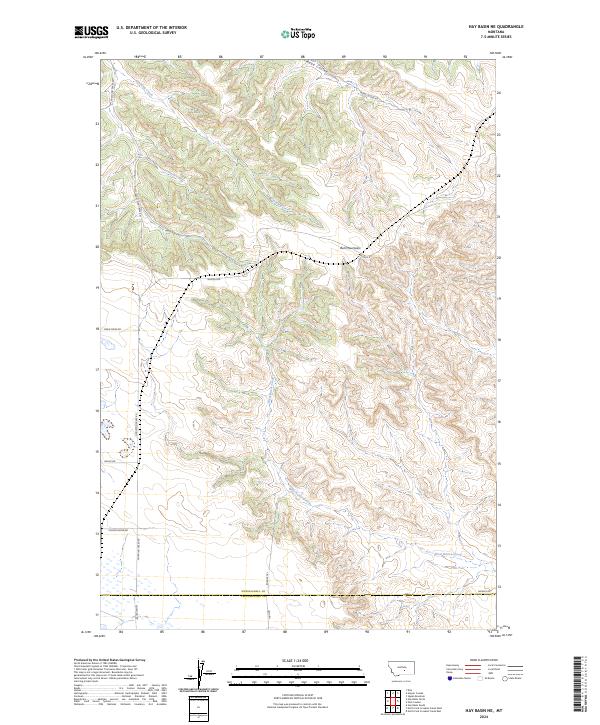
2024 Map of Hay Basin NE
USGS Topo · Published 2024About this map
Bull Mountains topography dominates this section of the Montana landscape, where intricate drainage systems like Road Coulee and Goulding Creek carve through the high country. The map captures a transition from these elevated breaks down toward the more level southern terrain near the border of Musselshell and Yellowstone counties. A significant portion of the southwestern quadrant is dedicated to a Waterfowl Production Area, highlighting the conservation value of the seasonal wetlands and riparian zones found along West Razor Creek. The network of local roads, including Schoolhouse Rd and Majerus Rd, provides a clear view of how rural access was established along the natural contours of the coulees and ridgelines. This modern survey reflects the enduring cattle-ranching and conservation character of the region, documenting the current state of land use and water management.
Find a feature on this map
23 named features on this map. Tap any name to fly to it.
Don’t see what you’re looking for? This feature index may not catch every label — zoom into the map to look around manually.
Map Details
Editions of this 2024 Hay Basin NE Map
This is the sole edition of this map. No revisions or reprints were ever made.
Other maps of this area

1954 · Roundup
USGS Topo · 1:250,000

1958 · Roundup
USGS Topo · 1:250,000

1979 · Roundup
USGS Topo · 1:100,000

1979 · Harper Coulee
USGS Topo · 1:24,000

1979 · Elso
USGS Topo · 1:24,000

1979 · Hay Basin NE
USGS Topo · 1:24,000
1980 · North Fork Crooked Creek East
USGS Topo · 1:24,000

1980 · Signal Mountain
USGS Topo · 1:24,000
1980 · North Fork Crooked Creek West
USGS Topo · 1:24,000
1980 · Park Coulee
USGS Topo · 1:24,000