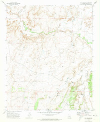
1971 Map of Hay Hollow
USGS Topo · Published 1973About this map
The Little Colorado River meanders through this portion of Navajo County, Arizona, shaping a landscape defined by seasonal drainages and cattle ranching infrastructure. During this early 1970s period, the area's geography is marked by an extensive network of water management features essential for livestock in the arid environment. Numerous man-made improvements are visible, including the Jim Dandy Tank, Antelope Tank, and Dry Lake Tank, alongside natural water sources like Horse Seep.
Find a feature on this map
19 named features on this map. Tap any name to fly to it.
Don’t see what you’re looking for? This feature index may not catch every label — zoom into the map to look around manually.
Map Details
Editions of this 1971 Hay Hollow Map
2 editions found
Other maps of this area

1886 · St Johns
USGS Topo · 1:250,000

1886 · Holbrook
USGS Topo · 1:250,000

1892 · St Johns
USGS Topo · 1:250,000

1893 · Holbrook
USGS Topo · 1:250,000

1912 · Petrified Forest
USGS Topo · 1:62,500

1954 · Holbrook
USGS Topo · 1:250,000

1954 · Saint Johns
USGS Topo · 1:250,000

1955 · Petrified Forest
USGS Topo · 1:62,500

1955 · Adamana 3 NE
USGS Topo · 1:24,000

1955 · St. Joseph 1 SE
USGS Topo · 1:24,000