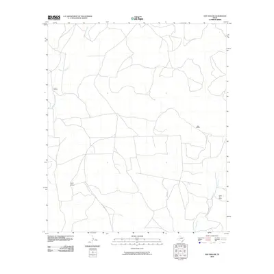
2010 Map of Hay Hollow
USGS Topo · Published 2010About this map
Middle Concho River winds through this West Texas landscape, defining a region where water sources were the primary driver of development. In 2010, the terrain is characterized by broad drainage systems like Hay Hollow and Coon Dive Draw, which flow toward the Kiowa Creek corridor. The geography reveals a sparse, ranch-oriented infrastructure where named landmarks are often functional water-drawing sites. Specific points of interest include the Model A Windmill and Scallop Tank Windmill, which stand as essential markers in an area otherwise dominated by open range and a grid of rural tracks. The layout of Middle Rd and Walker Rd illustrates the modern connectivity of this ranching country, showing how 21st-century land use continues to follow the natural contours of the Concho River basin.
Find a feature on this map
8 named features on this map. Tap any name to fly to it.
Don’t see what you’re looking for? This feature index may not catch every label — zoom into the map to look around manually.
Map Details
Editions of this 2010 Hay Hollow Map
This is the sole edition of this map. No revisions or reprints were ever made.
Other maps of this area

1921 · Ketchum Mountain
USGS Topo · 1:62,500

1923 · Ketchum Mountain
USGS Topo · 1:62,500

1954 · San Angelo
USGS Topo · 1:250,000

1958 · San Angelo
USGS Topo · 1:250,000

1965 · San Angelo
USGS Topo · 1:250,000

1970 · South Mustang Draw NE
USGS Topo · 1:24,000

1973 · Hay Hollow
USGS Topo · 1:24,000
1973 · Bradford Draw
USGS Topo · 1:24,000

1973 · Three Bluff Draw
USGS Topo · 1:24,000
1973 · Coon Dive Draw
USGS Topo · 1:24,000