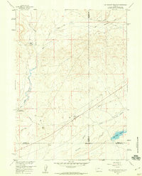
1958 Map of Hay Meadow Reservoir
USGS Topo · Published 1960About this map
Emigrant Trail tracks across this high plains landscape at the convergence of Sublette, Fremont, and Sweetwater counties. This 1958 survey records the historical significance of the Oregon Trail corridor, specifically marking the Dry Sandy Stage and Pony Express Sta Site and the McCann Ranch (Historical Site) (Stage Sta). These landmarks represent critical waypoints for mid-19th-century travelers through Wyoming's arid interior. The terrain is defined by seasonal watercourses like Dry Sandy Creek, Pacific Creek, and Whitehorse Creek, which dictated the path of westward expansion. In the southeast, the Hay Meadow Reservoir stands as a modern modification of the drainage patterns of Hay Meadow Creek. The presence of several Historical Monuments along the wagon ruts emphasizes the enduring cultural importance of this high-desert passage.
Find a feature on this map
18 named features on this map. Tap any name to fly to it.
Don’t see what you’re looking for? This feature index may not catch every label — zoom into the map to look around manually.
Map Details
Editions of this 1958 Hay Meadow Reservoir Map
3 editions found
Other maps of this area

1955 · Lander
USGS Topo · 1:250,000

1958 · Lander
USGS Topo · 1:250,000

1958 · Parting of the Ways
USGS Topo · 1:62,500

1958 · Essex Mountain
USGS Topo · 1:62,500

1958 · Hay Meadow Reservoir
USGS Topo · 1:24,000

1958 · Tule Butte
USGS Topo · 1:24,000

1958 · Pacific Springs
USGS Topo · 1:24,000

1958 · Parting of the Ways
USGS Topo · 1:24,000

1958 · Freighter Gap
USGS Topo · 1:62,500

1961 · Lander
USGS Topo · 1:250,000