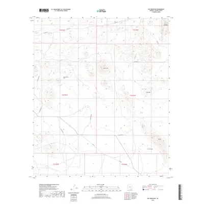
2018 Map of Hay Mountain
USGS Topo · Published 2018About this map
The Dragoon Mountains anchor the northeastern corner of this arid landscape, where the high desert floor is shaped by a network of seasonal watercourses and drainage features. The terrain is defined by prominent rises like Stockton Hill and Hay Mtn, with the dry channels of Stockton Draw and Government Draw cutting through the basin. This survey documents the ranching and range infrastructure of the early 21st century, detailing isolated water sources such as Antelope Spring, Reeves Tank, and Thompson Tank which are vital in this climate. A sparse grid of local roads, including Gleeson Rd and S Wild West Rd, provides access across the various townships. This topographic record serves as a baseline for understanding the land use and natural hydrology of the region before further modern developments or changes in the southwestern water table occur.
Find a feature on this map
24 named features on this map. Tap any name to fly to it.
Don’t see what you’re looking for? This feature index may not catch every label — zoom into the map to look around manually.
Map Details
Editions of this 2018 Hay Mountain Map
This is the sole edition of this map. No revisions or reprints were ever made.
Other maps of this area

1915 · Benson
USGS Topo · 1:125,000

1916 · Pearce
USGS Topo · 1:125,000

1922 · St. David
USGS Topo · 1:62,500

1925 · Gleeson
USGS Topo · 1:62,500

1926 · Courtland
USGS Topo · 1:62,500

1932 · Fairbank
USGS Topo · 1:62,500

1943 · Benson
USGS Topo · 1:125,000

1952 · Tombstone SE
USGS Topo · 1:24,000
1952 · Tombstone
USGS Topo · 1:24,000
1952 · Tombstone
USGS Topo · 1:62,500