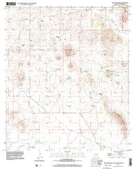
1996 Map of Hay Mountain
USGS Topo · Published 2002About this map
Stockton Hill and the southeastern reaches of the Dragoon Mts anchor this late-twentieth-century landscape in Cochise County. The map captures a high-desert environment defined by ranching and mineral exploration, evidenced by working outposts like Reeves Ranch and H O Davis Ranch. Water remains the central challenge and defining feature of the area, with numerous infrastructure markers such as Deep Well Windmill, Mesquite Windmill, and Thompson Tank scattered across the arid terrain. The legacy of prospecting is visible on the eastern slopes of Signal Hill, where the map identifies Gold Camp alongside various unnamed Shafts and Prospects. A complex network of drainage systems, including Stockton Draw and Government Draw, shapes the topography leading toward the prominent rise of Hay Mountain in the southeast.
Find a feature on this map
27 named features on this map. Tap any name to fly to it.
Don’t see what you’re looking for? This feature index may not catch every label — zoom into the map to look around manually.
Map Details
Editions of this 1996 Hay Mountain Map
This is the sole edition of this map. No revisions or reprints were ever made.
Other maps of this area

1915 · Benson
USGS Topo · 1:125,000

1916 · Pearce
USGS Topo · 1:125,000

1922 · St. David
USGS Topo · 1:62,500

1925 · Gleeson
USGS Topo · 1:62,500

1926 · Courtland
USGS Topo · 1:62,500

1932 · Fairbank
USGS Topo · 1:62,500

1943 · Benson
USGS Topo · 1:125,000

1952 · Tombstone SE
USGS Topo · 1:24,000
1952 · Tombstone
USGS Topo · 1:24,000
1952 · Tombstone
USGS Topo · 1:62,500