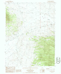
1986 Map of Hay Ranch
USGS Topo · Published 1986About this map
Hay Meadow and the surrounding basin of the Kobeh Valley dominate this mid-1980s provisional survey of central Nevada. The landscape is defined by the transition from the high peaks of the Mahogany Hills and Lone Mountain down to the watering points at Hay Ranch. Human activity is concentrated around these water sources and mineral extraction, with a documented mineshaft and multiple prospects scattered along the mountain flanks. The infrastructure of the era is represented by a Wooden Pole Trans Line cutting across the valley floor, connecting the isolated ranching and mining outposts. The presence of several wells and a spring underscores the critical importance of water rights and management in the arid corridor between Antelope Valley and the neighboring hills.
Find a feature on this map
17 named features on this map. Tap any name to fly to it.
Don’t see what you’re looking for? This feature index may not catch every label — zoom into the map to look around manually.
Map Details
Editions of this 1986 Hay Ranch Map
This is the sole edition of this map. No revisions or reprints were ever made.
Other maps of this area

1926 · Roberts Mountains
USGS Topo · 1:250,000

1929 · Roberts Mountains
USGS Topo · 1:250,000

1955 · Millett
USGS Topo · 1:250,000

1956 · Bellevue Peak
USGS Topo · 1:62,500

1956 · Bartine Ranch
USGS Topo · 1:62,500

1956 · Antelope Peak
USGS Topo · 1:62,500

1956 · Whistler Mtn
USGS Topo · 1:62,500

1959 · Millett
USGS Topo · 1:250,000

1978 · Summit Mountain
USGS Topo · 1:100,000

1979 · Simpson Park Mtns
USGS Topo · 1:100,000