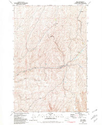
1981 Map of Hay
USGS Topo · Published 1981About this map
Alkali Flat Creek and Mud Flat Creek define the drainage patterns of this rural Whitman County landscape, where grain production and rail logistics dominate the local economy. The settlement of Hay serves as a central hub, evidenced by the presence of Grain Elevators and a local Cem, situated along the tracks of the Union Pacific railroad. This transportation corridor was essential for moving harvests from the surrounding high ground.
Find a feature on this map
19 named features on this map. Tap any name to fly to it.
Don’t see what you’re looking for? This feature index may not catch every label — zoom into the map to look around manually.
Map Details
Editions of this 1981 Hay Map
This is the sole edition of this map. No revisions or reprints were ever made.
Other maps of this area

1948 · Starbuck
USGS Topo · 1:62,500

1950 · La Crosse
USGS Topo · 1:62,500

1950 · Starbuck
USGS Topo · 1:62,500

1950 · Hay
USGS Topo · 1:62,500

1950 · Benge
USGS Topo · 1:62,500

1952 · Hay
USGS Topo · 1:62,500

1952 · La Crosse
USGS Topo · 1:62,500

1952 · Benge
USGS Topo · 1:62,500

1953 · Walla Walla
USGS Topo · 1:250,000

1955 · Pullman
USGS Topo · 1:250,000