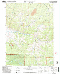
2000 Map of Hayden Gulch
USGS Topo · Published 2004About this map
The Williams Mountains and the drainage of the East Fork Williams Fork define this area of Colorado at the turn of the millennium. The landscape is a mix of high-altitude water management and industrial activity within the Routt National Forest. Numerous small-scale water storage sites, including Dillabaugh Reservoir, Detwiller Reservoir, and Maud Wise Reservoir, are scattered throughout the terrain, reflecting the critical role of water diversion in this region.
Find a feature on this map
33 named features on this map. Tap any name to fly to it.
Don’t see what you’re looking for? This feature index may not catch every label — zoom into the map to look around manually.
Map Details
Editions of this 2000 Hayden Gulch Map
This is the sole edition of this map. No revisions or reprints were ever made.
Other maps of this area

1916 · Daton Peak
USGS Topo · 1:62,500

1920 · Daton Peak
USGS Topo · 1:62,500

1924 · Mt. Harris
USGS Topo · 1:48,000

1926 · Mount Harris
USGS Topo · 1:62,500

1954 · Craig
USGS Topo · 1:250,000

1957 · Craig
USGS Topo · 1:250,000

1958 · Craig
USGS Topo · 1:250,000

1960 · Craig
USGS Topo · 1:250,000

1962 · Craig
USGS Topo · 1:250,000

1964 · Craig
USGS Topo · 1:250,000