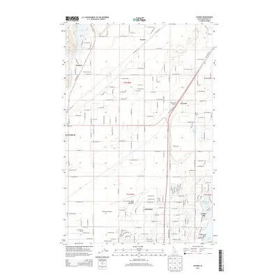
2013 Map of Hayden
USGS Topo · Published 2013About this map
Rathdrum Prairie and the Purcell Trench dominate this 2013 landscape, illustrating the suburban and rural expansion north of Coeur d'Alene. This modern survey detail shows a transition from the agricultural expanses of the prairie to the residential development surrounding Hayden Lake and its sister community, Honeysuckle Beach. Transportation networks are heavily emphasized, including the primary corridor of the N Government Way and several local aviation facilities such as Ranch Aero Airport and the Pappy Boyington Field Airport. Small historic pockets like Garwood and Ramsey remain visible alongside newer infrastructure. The map also records vital local landmarks like Pine Grove Cem and Rimrock Cem, and water features ranging from the Mikelton Canal to the southern tip of Twin Lakes at the northern margin.
Find a feature on this map
80 named features on this map. Tap any name to fly to it.
Don’t see what you’re looking for? This feature index may not catch every label — zoom into the map to look around manually.
Map Details
Editions of this 2013 Hayden Map
This is the sole edition of this map. No revisions or reprints were ever made.
Other maps of this area

1903 · Rathdrum
USGS Topo · 1:125,000

1955 · Spokane
USGS Topo · 1:250,000

1957 · Coeur D'Alene
USGS Topo · 1:62,500

1957 · Lane
USGS Topo · 1:62,500

1958 · Spokane
USGS Topo · 1:250,000

1961 · Hayden
USGS Topo · 1:24,000

1961 · Rathdrum
USGS Topo · 1:24,000

1961 · Spirit Lake East
USGS Topo · 1:24,000

1961 · Athol
USGS Topo · 1:24,000
1961 · Spirit Lake West
USGS Topo · 1:24,000