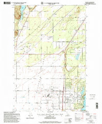
1996 Map of Hayden
USGS Topo · Published 1999About this map
Hayden and Hayden Lake anchor the southeastern corner of this landscape, where the residential and recreational development of Kootenai County meets the broad expanse of the Prairie and Rathdrum terrain. The map traces the specialized infrastructure of the late twentieth century, including the Coeur d'Alene Air Terminal and the Sanitary Landfill within the Purcell Trench. Earlier layers of local history remain visible through rural features like Pine Grove Cemetery, Rimrock Cemetery, and the Hayden Lake Elementary School. Transportation corridors such as Government Way and a Paved Bicycle Path parallel the rail lines, while smaller clusters like Garwood, Ramsey, and Sturgeon dot the landscape. To the north, the waters of Twin Lakes and Twin Lakes Station mark the edge of the more level prairie before the terrain begins its ascent.
Find a feature on this map
45 named features on this map. Tap any name to fly to it.
Don’t see what you’re looking for? This feature index may not catch every label — zoom into the map to look around manually.
Map Details
Editions of this 1996 Hayden Map
This is the sole edition of this map. No revisions or reprints were ever made.
Other maps of this area

1903 · Rathdrum
USGS Topo · 1:125,000

1955 · Spokane
USGS Topo · 1:250,000

1957 · Coeur D'Alene
USGS Topo · 1:62,500

1957 · Lane
USGS Topo · 1:62,500

1958 · Spokane
USGS Topo · 1:250,000

1961 · Hayden
USGS Topo · 1:24,000

1961 · Rathdrum
USGS Topo · 1:24,000

1961 · Spirit Lake East
USGS Topo · 1:24,000

1961 · Athol
USGS Topo · 1:24,000
1961 · Spirit Lake West
USGS Topo · 1:24,000