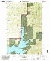
1996 Map of Hayden Lake
USGS Topo · Published 1999About this map
Hayden Lake serves as the central focal point of this late 20th-century landscape, characterized by its complex shoreline of numerous points and bays such as O'Rourke Bay and Cramps Bay. Much of the eastern and northern terrain falls within the Coeur d'Alene National Forest, where the topography rises toward Hollister Mountain and Hudlow Mountain. The map illustrates a balance between protected forest lands and lakeside recreation, evidenced by the English Point National Recreation Trail and facilities like Camp Mi-Voden. Small settlements such as Chilco and Clarksville are noted alongside legacy industrial sites, including the Shamrock Mine and Commonwealth Mine. The presence of a Gaging Station and the specific recording of Elevation 2238 July 1958 provide hydrological context for the lake's management at the time of the survey.
Find a feature on this map
57 named features on this map. Tap any name to fly to it.
Don’t see what you’re looking for? This feature index may not catch every label — zoom into the map to look around manually.
Map Details
Editions of this 1996 Hayden Lake Map
This is the sole edition of this map. No revisions or reprints were ever made.
Other maps of this area

1903 · Rathdrum
USGS Topo · 1:125,000

1955 · Spokane
USGS Topo · 1:250,000

1957 · Coeur D'Alene
USGS Topo · 1:62,500

1957 · Lane
USGS Topo · 1:62,500

1958 · Spokane
USGS Topo · 1:250,000

1961 · Hayden
USGS Topo · 1:24,000

1961 · Bayview
USGS Topo · 1:24,000

1961 · Spirit Lake East
USGS Topo · 1:24,000

1961 · Athol
USGS Topo · 1:24,000

1961 · Spirit Lake
USGS Topo · 1:62,500