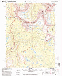
1996 Map of Hayden Peak
USGS Topo · Published 2000About this map
Hayden Peak and Mount Agassiz anchor this high-elevation survey of the Uintas, where the convergence of the Wasatch National Forest, Cache National Forest, and Ashley National Forest creates a complex wilderness boundary. The landscape is defined by vast glacial cirques and basins, including the densely clustered water bodies of Naturalist Basin and the Four Lakes Basin. This 1990s revision details a remote network of trails such as the Highline Trail and the Skinner Cutoff, which facilitate travel through the High Uintas Wilderness. The map captures the hydrological significance of the region, tracing numerous alpine sources like Pigeon Milk Spring and Governor Dern Lake that feed into the Fish Creek drainage. It also marks historical administrative lines, including the winding borders between Summit and Duchesne Counties.
Find a feature on this map
91 named features on this map. Tap any name to fly to it.
Don’t see what you’re looking for? This feature index may not catch every label — zoom into the map to look around manually.
Map Details
Editions of this 1996 Hayden Peak Map
This is the sole edition of this map. No revisions or reprints were ever made.
Other maps of this area

1885 · Uinta
USGS Topo · 1:250,000

1901 · Hayden Peak
USGS Topo · 1:125,000

1903 · Hayden Peak
USGS Topo · 1:125,000

1954 · Salt Lake City
USGS Topo · 1:250,000

1958 · Salt Lake City
USGS Topo · 1:250,000

1960 · Salt Lake City
USGS Topo · 1:250,000

1967 · Explorer Peak
USGS Topo · 1:24,000
1967 · Tworoose Pass
USGS Topo · 1:24,000
1967 · Red Knob
USGS Topo · 1:24,000
1972 · Iron Mine Mountain
USGS Topo · 1:24,000