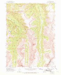
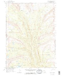
1967 Map of Red Knob
USGS Topo · Published 1969About this map
Mount Beulah and the towering formation known as The Cathedral dominate this high-elevation landscape along the boundary of Wasatch National Forest and Ashley National Forest. This 1967 field survey documents the complex drainage systems that define the High Uintas, where the East Fork Bear River begins its descent alongside the Left Hand Fork and Right Hand Fork. The map shows a region accessible primarily by a network of Pack Trails and Jeep Trails, linking remote high-country basins such as Cataract Basin. Significant peaks and passes, including Yard Peak, Red Knob, and Deadman Pass, serve as critical landmarks for navigating the divide between Summit and Duchesne counties. Alpine water bodies like Allsop Lake, Norice Lake, and Priord Lake are clearly delineated, illustrating the glaciated character of this wilderness area.
Find a feature on this map
28 named features on this map. Tap any name to fly to it.
Don’t see what you’re looking for? This feature index may not catch every label — zoom into the map to look around manually.
Map Details
Editions of this 1967 Red Knob Map
2 editions found
Other maps of this area

1885 · Uinta
USGS Topo · 1:250,000

1901 · Hayden Peak
USGS Topo · 1:125,000

1903 · Hayden Peak
USGS Topo · 1:125,000

1954 · Salt Lake City
USGS Topo · 1:250,000

1958 · Salt Lake City
USGS Topo · 1:250,000

1960 · Salt Lake City
USGS Topo · 1:250,000

1967 · Explorer Peak
USGS Topo · 1:24,000
1967 · Mount Lovenia
USGS Topo · 1:24,000
1967 · Elizabeth Mtn
USGS Topo · 1:24,000
1967 · Oweep Creek
USGS Topo · 1:24,000