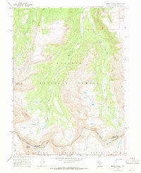
1967 Map of Mount Lovenia
USGS Topo · Published 1968About this map
High-altitude ridges and glacial headwaters define this section of the Uinta Mountains in the late 1960s, dominated by the massif of Mount Lovenia and the sharp profile of Tokewanna Peak. The landscape is a complex network of alpine drainage systems, where the Middle Fork Blacks Fork and East Fork Blacks Fork carve deep paths through the high country. An important historical alignment, the Old Indian Treaty Boundary, runs through the southern portion of the map, marked by a corresponding trail that follows the divide. This boundary represents a significant jurisdictional and cultural demarcation within the Wasatch National Forest, separating the northern drainage basins from the Lake Fork River system to the south. Hikers and surveyors of this era relied on established routes like the Little East Fork Blacks Fork Trail and the passage through Squaw Pass to navigate the steep, unpopulated terrain between Bald Mtn and the southern peaks.
Find a feature on this map
20 named features on this map. Tap any name to fly to it.
Don’t see what you’re looking for? This feature index may not catch every label — zoom into the map to look around manually.
Map Details
Editions of this 1967 Mount Lovenia Map
2 editions found
Other maps of this area

1885 · Uinta
USGS Topo · 1:250,000

1901 · Hayden Peak
USGS Topo · 1:125,000

1903 · Hayden Peak
USGS Topo · 1:125,000

1905 · Gilbert Peak
USGS Topo · 1:125,000

1906 · Gilbert Peak
USGS Topo · 1:125,000

1954 · Salt Lake City
USGS Topo · 1:250,000

1958 · Salt Lake City
USGS Topo · 1:250,000

1960 · Salt Lake City
USGS Topo · 1:250,000

1967 · Explorer Peak
USGS Topo · 1:24,000
1967 · Elizabeth Mtn
USGS Topo · 1:24,000