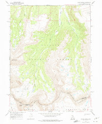
1967 Map of Mount Lovenia
USGS Topo · Published 1975About this map
Mount Lovenia and Tokewanna Peak anchor this high-altitude landscape in the late 1960s, marking the dramatic topography where the Wasatch National Forest meets the Ashley National Forest. The map documents a complex hydrological network defined by the Middle Fork Blacks Fork and the East Fork Blacks Fork, along with several unnamed Springs. Of particular interest to historians is the Old Indian Treaty Boundary, which cuts across the southern portion of the sheet near Squaw Pass, delineating the historical intersection of administrative and indigenous territories. The drainage of the Lake Fork River and Queeep Creek underscores the area's importance as a watershed. Transportation is limited to a primitive network of Pack Trails, emphasizing the remote character of this mountain terrain before modern road development reached these elevations.
Find a feature on this map
16 named features on this map. Tap any name to fly to it.
Don’t see what you’re looking for? This feature index may not catch every label — zoom into the map to look around manually.
Map Details
Editions of this 1967 Mount Lovenia Map
2 editions found
Other maps of this area

1885 · Uinta
USGS Topo · 1:250,000

1901 · Hayden Peak
USGS Topo · 1:125,000

1903 · Hayden Peak
USGS Topo · 1:125,000

1905 · Gilbert Peak
USGS Topo · 1:125,000

1906 · Gilbert Peak
USGS Topo · 1:125,000

1954 · Salt Lake City
USGS Topo · 1:250,000

1958 · Salt Lake City
USGS Topo · 1:250,000

1960 · Salt Lake City
USGS Topo · 1:250,000

1967 · Explorer Peak
USGS Topo · 1:24,000
1967 · Mount Lovenia
USGS Topo · 1:24,000