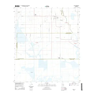
2015 Map of Hayes
USGS Topo · Published 2015About this map
Hayes and Bell City anchor this landscape where the coastal prairies meet the wetlands of south Louisiana. The geography is defined by a rigorous grid of section lines and drainage infrastructure, most notably the Bell City Drainage Canal and the meandering course of Bayou Lacassine, which serves as a natural boundary between Calcasieu and Jefferson Davis Parishes. Small clusters of settlement at Rossignol, Oak Island, and Pine Island dot the map, connected by a network of rural roads that often bear the names of local families, such as Joe Primeaux Rd and Oliver Hayes Rd. Further south, the terrain transitions toward Wild Island and the marshes bordering Cameron Parish. The presence of the Illinois Plant near the junction of Illinois Plant Rd and Bass Rd points to the area's agricultural or industrial land use amidst the low-lying coastal plain.
Find a feature on this map
35 named features on this map. Tap any name to fly to it.
Don’t see what you’re looking for? This feature index may not catch every label — zoom into the map to look around manually.
Map Details
Editions of this 2015 Hayes Map
This is the sole edition of this map. No revisions or reprints were ever made.
Other maps of this area

1932 · Lake Charles NE
USGS Topo · 1:31,680

1932 · Lake Charles SE
USGS Topo · 1:31,680

1934 · Lake Misere
USGS Topo · 1:24,000

1934 · Boudreaux Lake
USGS Topo · 1:24,000

1934 · Latania Lake
USGS Topo · 1:24,000

1935 · Lake Misere
USGS Topo · 1:31,680

1935 · Latania Lake
USGS Topo · 1:31,680

1935 · Boudreaux Lake
USGS Topo · 1:31,680

1942 · Lake Charles
USGS Topo · 1:62,500

1946 · Lacassine
USGS Topo · 1:31,680