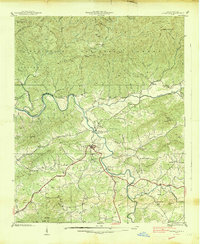
1938 Map of Hayesville
USGS Topo · Published 1938About this map
Hayesville sits at the heart of this pre-war survey, where the Hiwassee River winds through the valley between the Nantahala Mountains and Tusquitee Mountains. The landscape is defined by its rural mountain community infrastructure, featuring a high density of small rural gathering places like Shady Grove Ch, Ledford Chapel, and the combined Fires Creek Ch and Sch. The presence of the Hayesville Reservoir and the Gaging Sta on the river indicates the early management of water resources within the Nantahala National Forest. Local travel relied on critical river crossings such as Sannerson Bridge and Herbert Bridge, connecting outlying settlements like Scrougetown and Tusquitee to the county seat. This topography captures Clay County just as its forest roads and mountain gaps were being formalized by the Tennessee Valley Authority and Geological Survey.
Find a feature on this map
62 named features on this map. Tap any name to fly to it.
Don’t see what you’re looking for? This feature index may not catch every label — zoom into the map to look around manually.
Map Details
Editions of this 1938 Hayesville Map
This is the sole edition of this map. No revisions or reprints were ever made.
Other maps of this area

1886 · Dahlonega
USGS Topo · 1:125,000

1892 · Dahlonega
USGS Topo · 1:125,000

1896 · Dahlonega
USGS Topo · 1:125,000

1903 · Dahlonega
USGS Topo · 1:125,000

1935 · Peachtree
USGS Topo · 1:24,000

1935 · Osborn
USGS Topo · 1:24,000

1935 · Shooting Creek
USGS Topo · 1:24,000

1935 · Topton
USGS Topo · 1:24,000

1935 · Marble
USGS Topo · 1:24,000

1935 · Wayah Bald
USGS Topo · 1:48,000