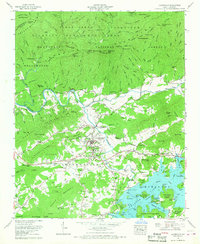
1966 Map of Hayesville
USGS Topo · Published 1968About this map
Hayesville serves as the focal point for this mid-1960s study of Clay County, situated at the confluence of the Hiwassee River and the expanding waters of Chatuge Lake. The landscape transition from the valley floor to the high peaks of the Valley River Mts and the Nantahala Mountains is marked by numerous family-named landmarks and rural institutions. Civic life is anchored by the Hayesville High Sch, Truett Memorial Ch, and the Hayesville Cem. Outside the town center, small communities like Blair and Matheson dot the roads leading toward the Nantahala National Forest. The map also captures significant infrastructure, including the Sanderson Bridge and the Lower Tusquitee Bridge, alongside recreational developments such as the Jackrabbit Campground and the Clay County Park near the lake shoreline.
Find a feature on this map
156 named features on this map. Tap any name to fly to it.
Don’t see what you’re looking for? This feature index may not catch every label — zoom into the map to look around manually.
Map Details
Editions of this 1966 Hayesville Map
3 editions found
Other maps of this area

1886 · Dahlonega
USGS Topo · 1:125,000

1892 · Dahlonega
USGS Topo · 1:125,000

1896 · Dahlonega
USGS Topo · 1:125,000

1903 · Dahlonega
USGS Topo · 1:125,000

1935 · Peachtree
USGS Topo · 1:24,000

1935 · Osborn
USGS Topo · 1:24,000

1935 · Shooting Creek
USGS Topo · 1:24,000

1935 · Topton
USGS Topo · 1:24,000

1935 · Marble
USGS Topo · 1:24,000

1935 · Wayah Bald
USGS Topo · 1:48,000