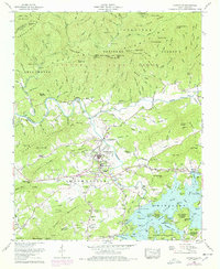
1966 Map of Hayesville
USGS Topo · Published 1978About this map
Hayesville serves as the focal point for this survey of the northern edges of Chatuge Lake, where the Hiwassee River meets the heavy timber of the Nantahala National Forest. The landscape is defined by the sharp transition from the broad valley floor to the peaks of the Tusquitee Mountains and the Valley River Mts. Local social and spiritual life is recorded through a dense network of country institutions, including the Truett Memorial Ch, George W Truett Camp, and the Hinton Rural Life Center. Infrastructure from the Tennessee Valley Authority era is prominent, specifically the Chatuge Dam and its associated power intake tower, which regulated the waters that transformed this mountain basin. For those tracing local families, the map identifies numerous small cemeteries and places of worship such as Philadelphia Church and Mcclure Cem.
Find a feature on this map
175 named features on this map. Tap any name to fly to it.
Don’t see what you’re looking for? This feature index may not catch every label — zoom into the map to look around manually.
Map Details
Editions of this 1966 Hayesville Map
3 editions found
Other maps of this area

1886 · Dahlonega
USGS Topo · 1:125,000

1892 · Dahlonega
USGS Topo · 1:125,000

1896 · Dahlonega
USGS Topo · 1:125,000

1903 · Dahlonega
USGS Topo · 1:125,000

1935 · Peachtree
USGS Topo · 1:24,000

1935 · Osborn
USGS Topo · 1:24,000

1935 · Shooting Creek
USGS Topo · 1:24,000

1935 · Topton
USGS Topo · 1:24,000

1935 · Marble
USGS Topo · 1:24,000

1935 · Wayah Bald
USGS Topo · 1:48,000