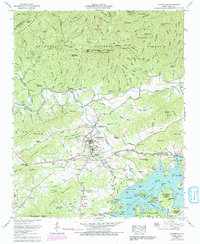
1966 Map of Hayesville
USGS Topo · Published 1991About this map
The mountain town of Hayesville serves as the focal point of this mid-1960s study, situated just north of the expansive Chatuge Lake. This area of Clay County is defined by the sharp convergence of the Hiwassee River and Tusquitee Creek, with the massive Chatuge Dam regulating the flow south of town. The landscape transitions from the developed center of the county seat to the protected ridges of the Nantahala National Forest, where features like Graveyard High Top and Omphus Ridge loom over the valley.
Find a feature on this map
128 named features on this map. Tap any name to fly to it.
Don’t see what you’re looking for? This feature index may not catch every label — zoom into the map to look around manually.
Map Details
Editions of this 1966 Hayesville Map
3 editions found
Other maps of this area

1886 · Dahlonega
USGS Topo · 1:125,000

1892 · Dahlonega
USGS Topo · 1:125,000

1896 · Dahlonega
USGS Topo · 1:125,000

1903 · Dahlonega
USGS Topo · 1:125,000

1935 · Peachtree
USGS Topo · 1:24,000

1935 · Osborn
USGS Topo · 1:24,000

1935 · Shooting Creek
USGS Topo · 1:24,000

1935 · Topton
USGS Topo · 1:24,000

1935 · Marble
USGS Topo · 1:24,000

1935 · Wayah Bald
USGS Topo · 1:48,000