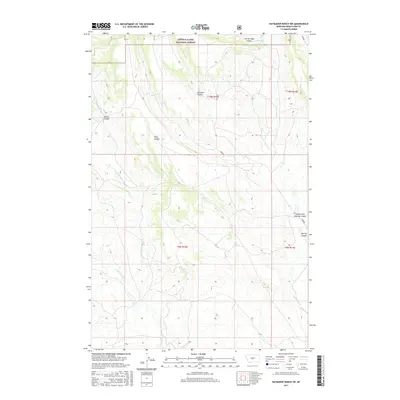
2017 Map of Haymaker Ranch SW
USGS Topo · Published 2017About this map
Lewis & Clark National Forest territory defines the northern reaches of this landscape, where the high plains of Wheatland County transition into protected timberland. The drainage network is the primary feature of this terrain, characterized by a series of coulees and creeks that cut through the open country. Watercourses such as Iron Springs Coulee and Barnhart Coulee indicate a seasonal hydrology common to this part of Montana. Further south, Daisy Dean Cr and its tributary, Dry Fork Daisy Dean Cr, snake through the section lines alongside Pierce Coulee. The eastern portion is marked by the presence of Trombone Cr and Haymaker Cr, while localized names like Clarks Fork Morrisy Coulee and Willis Coulee suggest the long-standing ranching history and family-named landmarks of this rural expanse.
Find a feature on this map
16 named features on this map. Tap any name to fly to it.
Don’t see what you’re looking for? This feature index may not catch every label — zoom into the map to look around manually.
Map Details
Editions of this 2017 Haymaker Ranch SW Map
This is the sole edition of this map. No revisions or reprints were ever made.
Other maps of this area

1886 · Little Belt Mts.
USGS Topo · 1:250,000

1894 · Little Belt Mts.
USGS Topo · 1:250,000

1897 · Little Belt Mts.
USGS Topo · 1:250,000

1898 · Little Belt Mts.
USGS Topo · 1:250,000

1902 · Little Belt Mts.
USGS Topo · 1:250,000

1948 · White Sulphur Springs
USGS Topo · 1:250,000

1958 · White Sulphur Springs
USGS Topo · 1:250,000

1961 · White Sulphur Springs
USGS Topo · 1:250,000

1965 · White Sulphur Springs
USGS Topo · 1:250,000
1972 · Daisy Peak
USGS Topo · 1:24,000