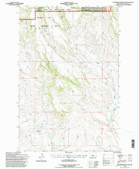
1995 Map of Haymaker Ranch SW
USGS Topo · Published 1997About this map
The Olaf Community Center stands as a lonely social landmark in this mid-1990s landscape of the Montana prairie. Situated in the northern reaches of Wheatland County, the terrain is defined by a dense network of coulees and forks draining the surrounding uplands. The Haymaker State Wildlife Management Area and the Lewis and Clark National Forest dominate the northwestern corner, where the Musselshell Ranger District maintains the forest boundary. Named drainage features like Barnhard Coulee, Morrisey Coulee, and Willis Coulee carve through the cattle-ranching country, converging toward the Clarks Fork. Traces of local industry appear in the form of a Gravel Pit near the center of the sheet, while the presence of a Flowing Well in the southwest suggests the vital importance of groundwater in this high plains environment.
Find a feature on this map
19 named features on this map. Tap any name to fly to it.
Don’t see what you’re looking for? This feature index may not catch every label — zoom into the map to look around manually.
Map Details
Editions of this 1995 Haymaker Ranch SW Map
This is the sole edition of this map. No revisions or reprints were ever made.
Other maps of this area

1886 · Little Belt Mts.
USGS Topo · 1:250,000

1894 · Little Belt Mts.
USGS Topo · 1:250,000

1897 · Little Belt Mts.
USGS Topo · 1:250,000

1898 · Little Belt Mts.
USGS Topo · 1:250,000

1902 · Little Belt Mts.
USGS Topo · 1:250,000

1948 · White Sulphur Springs
USGS Topo · 1:250,000

1958 · White Sulphur Springs
USGS Topo · 1:250,000

1961 · White Sulphur Springs
USGS Topo · 1:250,000

1965 · White Sulphur Springs
USGS Topo · 1:250,000
1972 · Daisy Peak
USGS Topo · 1:24,000