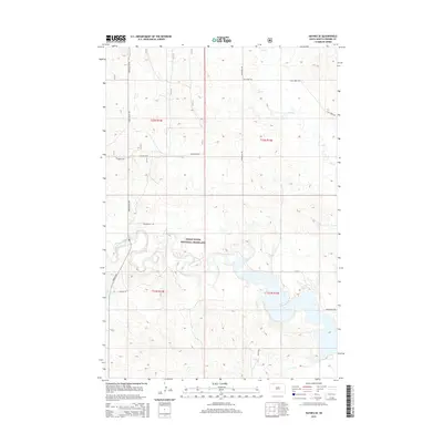
2015 Map of Haynes SE
USGS Topo · Published 2015About this map
The Grand River National Grassland dominates this landscape in Perkins County, where the wide, winding course of the North Fork Grand River cuts through the southern sections. This 2015 survey illustrates a sprawling prairie environment managed for conservation and grazing, punctuated by small-scale water management features like the Johnson Dam. The terrain is defined by a sparse but structured network of section-line roads, providing access to remote ranching and public lands.
Find a feature on this map
16 named features on this map. Tap any name to fly to it.
Don’t see what you’re looking for? This feature index may not catch every label — zoom into the map to look around manually.
Map Details
Editions of this 2015 Haynes SE Map
This is the sole edition of this map. No revisions or reprints were ever made.
Other maps of this area

1954 · Lemmon
USGS Topo · 1:250,000

1957 · Lemmon
USGS Topo · 1:250,000

1974 · White Butte
USGS Topo · 1:24,000

1974 · Lemmon
USGS Topo · 1:24,000

1974 · Haynes
USGS Topo · 1:24,000

1983 · Haynes SE
USGS Topo · 1:24,000

1983 · Bison NE
USGS Topo · 1:24,000

1983 · Meadow NW
USGS Topo · 1:24,000

1983 · Bison NW
USGS Topo · 1:24,000
1983 · Sommerville
USGS Topo · 1:24,000