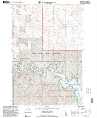
1998 Map of Haynes SE
USGS Topo · Published 2001About this map
Shadehill Reservoir and the Grand River dominate this landscape in Perkins County, where the sprawling Grand River National Grassland meets the Shadehill State Recreation Area. The map reveals a sparsely populated ranching territory characterized by family holdings such as the Haugen Ranch, N Ham Ranch, and J Johnson Ranch. Local infrastructure for water management and public access is evident through the Gaging Station, Johnson Dam, and the West Boat Launch Area on the reservoir's western arm. For those researching local history, the location of the Adkins School and various tanks and springs provide a clear picture of how water and education were organized across the plains during the late twentieth century. The terrain is defined by the winding course of Flat Creek and the varied elevation of the Liberty township region, showing the intersection of managed federal lands and private agriculture.
Find a feature on this map
17 named features on this map. Tap any name to fly to it.
Don’t see what you’re looking for? This feature index may not catch every label — zoom into the map to look around manually.
Map Details
Editions of this 1998 Haynes SE Map
This is the sole edition of this map. No revisions or reprints were ever made.
Other maps of this area

1954 · Lemmon
USGS Topo · 1:250,000

1957 · Lemmon
USGS Topo · 1:250,000

1974 · White Butte
USGS Topo · 1:24,000

1974 · Lemmon
USGS Topo · 1:24,000

1974 · Haynes
USGS Topo · 1:24,000

1983 · Haynes SE
USGS Topo · 1:24,000

1983 · Bison NE
USGS Topo · 1:24,000

1983 · Meadow NW
USGS Topo · 1:24,000

1983 · Bison NW
USGS Topo · 1:24,000
1983 · Sommerville
USGS Topo · 1:24,000