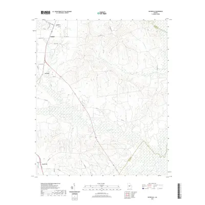
2020 Map of Hayneville
USGS Topo · Published 2020About this map
Hayneville and the southern reaches of Perry define the settled landscape of this central Georgia corridor during the late 2010s. The terrain is deeply carved by a network of waterways including the Ocmulgee River, which forms a natural boundary in the northeast corner, and the extensive wetlands surrounding Big Indian Creek. Local transit and land use are visible through the primary artery of Golden Isl Pkwy and smaller community names like Kathleen and Sand Bed. Genealogists will find the Hayneville Cemetery marked near the southern edge of the quadrangle. The map captures the transition from small-town centers to the dense creek drainage systems of Big Grocery Creek and Mossy Creek, revealing how the low-lying topography has historically shaped road placement and residential patterns throughout Houston County.
Find a feature on this map
33 named features on this map. Tap any name to fly to it.
Don’t see what you’re looking for? This feature index may not catch every label — zoom into the map to look around manually.
Map Details
Editions of this 2020 Hayneville Map
This is the sole edition of this map. No revisions or reprints were ever made.
Other maps of this area

1956 · Cochran
USGS Topo · 1:62,500

1956 · Perry
USGS Topo · 1:62,500

1956 · Warner Robins
USGS Topo · 1:62,500

1956 · Jeffersonville
USGS Topo · 1:62,500

1957 · Macon
USGS Topo · 1:250,000

1958 · Macon
USGS Topo · 1:250,000

1964 · Macon
USGS Topo · 1:250,000

1973 · Hayneville
USGS Topo · 1:24,000

1973 · Klondike
USGS Topo · 1:24,000
1973 · Unadilla
USGS Topo · 1:24,000