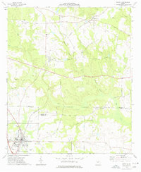
1973 Map of Unadilla
USGS Topo · Published 1977About this map
The Southern Railway corridor anchors this 1970s landscape, connecting the town of Unadilla with the smaller communities of Elko and Grovania to the north. This central Georgia region is defined by its agricultural layout, where fine red dashed lines indicate field and fence boundaries visible from 1973 aerial photography. The boundary between Houston Co and Dooly Co cuts across the southern portion of the map, just north of the Unadilla settlement.
Find a feature on this map
42 named features on this map. Tap any name to fly to it.
Don’t see what you’re looking for? This feature index may not catch every label — zoom into the map to look around manually.
Map Details
Editions of this 1973 Unadilla Map
This is the sole edition of this map. No revisions or reprints were ever made.
Other maps of this area

1956 · Perry
USGS Topo · 1:62,500

1957 · Macon
USGS Topo · 1:250,000

1958 · Macon
USGS Topo · 1:250,000

1964 · Macon
USGS Topo · 1:250,000

1971 · Pineview NW
USGS Topo · 1:24,000

1971 · Henderson
USGS Topo · 1:24,000

1971 · Pinehurst
USGS Topo · 1:24,000

1972 · Perry West
USGS Topo · 1:24,000

1972 · Finleyson West
USGS Topo · 1:24,000

1973 · Hayneville
USGS Topo · 1:24,000