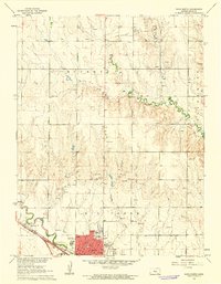
1961 Map of Hays North
USGS Topo · Published 1962About this map
The growing city of Hays anchors this 1961 survey, showing a landscape defined by education, religion, and the petroleum industry. The southern portion of the map is dominated by the grid of the city, featuring numerous institutions such as St Joseph Academy, Fort Hays State College, and several parochial and public schools like St Joseph Sch and Lincoln Sch. The city's northern expansion is hemmed by the Union Pacific railroad corridor and the winding course of Big Creek.
Find a feature on this map
24 named features on this map. Tap any name to fly to it.
Don’t see what you’re looking for? This feature index may not catch every label — zoom into the map to look around manually.
Map Details
Editions of this 1961 Hays North Map
3 editions found
Other maps of this area

1896 · Hays
USGS Topo · 1:125,000

1896 · Plainville
USGS Topo · 1:125,000

1955 · Great Bend
USGS Topo · 1:250,000

1955 · Beloit
USGS Topo · 1:250,000

1957 · Great Bend
USGS Topo · 1:250,000

1958 · Great Bend
USGS Topo · 1:250,000

1959 · Beloit
USGS Topo · 1:250,000

1961 · Yocemento
USGS Topo · 1:24,000

1961 · Hays South
USGS Topo · 1:24,000

1961 · Catharine
USGS Topo · 1:24,000