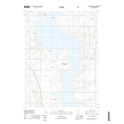
2017 Map of Haystack Buttes North
USGS Topo · Published 2017About this map
Ashley National Forest lands dominate this high-desert landscape in Sweetwater County, where the topography is defined by the expansive waters of Flaming Gorge Reservoir. This 2017 survey captures the intersection of dramatic canyon landforms and the managed recreation of the reservoir. Notable terrain features like Big Bend and Lowe Canyon provide a glimpse into the drainage patterns that feed into the reservoir, while Haystack Buttes stands as a prominent landmark in the southwestern portion of the map. The map details the network of small drainages such as Buckboard Wash and Upper Marsh Cr that carve through Squaw Hollow, showing how the natural hydrology interacts with the modern infrastructure of Co RD 38. This representation is essential for understanding the contemporary geography of these protected federal lands and the remote backcountry of southern Wyoming.
Find a feature on this map
15 named features on this map. Tap any name to fly to it.
Don’t see what you’re looking for? This feature index may not catch every label — zoom into the map to look around manually.
Map Details
Editions of this 2017 Haystack Buttes North Map
This is the sole edition of this map. No revisions or reprints were ever made.
Other maps of this area

1954 · Rock Springs
USGS Topo · 1:250,000

1957 · Currant Creek Ranch
USGS Topo · 1:62,500

1957 · Mc Kinnon Junction
USGS Topo · 1:62,500

1957 · Firehole Basin
USGS Topo · 1:62,500

1958 · Rock Springs
USGS Topo · 1:250,000

1962 · Rock Springs
USGS Topo · 1:250,000

1966 · Firehole Basin
USGS Topo · 1:62,500

1966 · Mc Kinnon Junction
USGS Topo · 1:62,500

1966 · Buckboard Crossing
USGS Topo · 1:62,500

1966 · Currant Creek Ranch
USGS Topo · 1:62,500