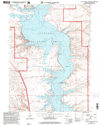
1996 Map of Haystack Buttes North
USGS Topo · Published 1999About this map
Flaming Gorge Reservoir dominates this high-desert landscape in Sweetwater County, where the Green River was transformed into a massive recreation and storage facility. The 1996 revision details the infrastructure developed within the Flaming Gorge National Recreation Area, from the Buckboard Marina and Buckboard Crossing in the north to boat launches like the Squaw Hollow Boat Ramp and Upper Marsh Creek Boat Ramp.
Find a feature on this map
21 named features on this map. Tap any name to fly to it.
Don’t see what you’re looking for? This feature index may not catch every label — zoom into the map to look around manually.
Map Details
Editions of this 1996 Haystack Buttes North Map
This is the sole edition of this map. No revisions or reprints were ever made.
Other maps of this area

1954 · Rock Springs
USGS Topo · 1:250,000

1957 · Currant Creek Ranch
USGS Topo · 1:62,500

1957 · Mc Kinnon Junction
USGS Topo · 1:62,500

1957 · Firehole Basin
USGS Topo · 1:62,500

1958 · Rock Springs
USGS Topo · 1:250,000

1962 · Rock Springs
USGS Topo · 1:250,000

1966 · Firehole Basin
USGS Topo · 1:62,500

1966 · Mc Kinnon Junction
USGS Topo · 1:62,500

1966 · Buckboard Crossing
USGS Topo · 1:62,500

1966 · Currant Creek Ranch
USGS Topo · 1:62,500