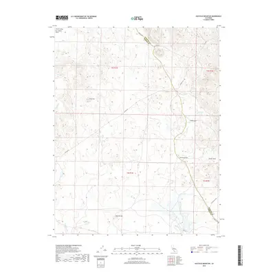
2018 Map of Haystack Mountain
USGS Topo · Published 2018About this map
Courthouse Rock and Haystack Mtn anchor this transition between the foothills and the flat expanse of the San Joaquin Valley. The map shows a complex drainage system flowing toward the valley floor, including Black Rascal Cr, Stony Cr, and the winding Burns Cr. These seasonal waterways cut through distinctive landforms like China Hat and the deep Toledo Gulch. Human infrastructure is largely confined to the winding paths of Hornitos Rd and La Paloma Rd, which follow the natural contours of the terrain as they approach the Mariposa County and Merced County line. The absence of dense development preserves the visibility of the Public Land Survey System grid, which is clearly delineated across township and range lines.
Find a feature on this map
24 named features on this map. Tap any name to fly to it.
Don’t see what you’re looking for? This feature index may not catch every label — zoom into the map to look around manually.
Map Details
Editions of this 2018 Haystack Mountain Map
This is the sole edition of this map. No revisions or reprints were ever made.
Other maps of this area

1893 · Sonora
USGS Topo · 1:125,000

1896 · Sonora
USGS Topo · 1:125,000

1897 · Sonora
USGS Topo · 1:125,000

1898 · Sonora
USGS Topo · 1:125,000

1914 · Merced
USGS Topo · 1:31,680

1915 · Owens Creek
USGS Topo · 1:31,680

1916 · Hopeton
USGS Topo · 1:31,680

1916 · Merced Falls
USGS Topo · 1:24,000

1917 · Merced
USGS Topo · 1:31,680
1918 · Snelling
USGS Topo · 1:31,680