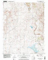
1999 Map of Haystack Mountain
USGS Topo · Published 2002About this map
The boundary between Mariposa and Merced counties cuts through a landscape shaped by both natural drainage and ranching activity in the late 20th century. Prominent geological features like China Hat and Courthouse Rock overlook a network of seasonal watercourses, including Black Rascal Creek and Stoney Creek. To the south, the namesake Haystack Mountain rises above the Burns Creek Dam area, where a reservoir and nearby Gaging Station indicate the region's managed water resources. Evidence of local industry is visible through the Quarry and scattered Tailings near Burns Creek, reflecting a history of resource extraction. Small family-run operations like La Paloma Ranch and Walts Ranch are connected by a system of rural roads such as Hornitos Road and Merced Falls Road, illustrating the sparse but enduring agricultural settlement pattern characteristic of this part of the California foothills.
Find a feature on this map
19 named features on this map. Tap any name to fly to it.
Don’t see what you’re looking for? This feature index may not catch every label — zoom into the map to look around manually.
Map Details
Editions of this 1999 Haystack Mountain Map
This is the sole edition of this map. No revisions or reprints were ever made.
Other maps of this area

1893 · Sonora
USGS Topo · 1:125,000

1896 · Sonora
USGS Topo · 1:125,000

1897 · Sonora
USGS Topo · 1:125,000

1898 · Sonora
USGS Topo · 1:125,000

1914 · Merced
USGS Topo · 1:31,680

1915 · Owens Creek
USGS Topo · 1:31,680

1916 · Hopeton
USGS Topo · 1:31,680

1916 · Merced Falls
USGS Topo · 1:24,000

1917 · Merced
USGS Topo · 1:31,680
1918 · Snelling
USGS Topo · 1:31,680