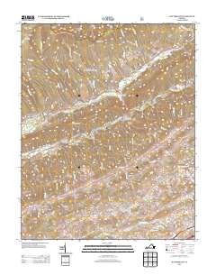
2013 Map of Hayters Gap
USGS Topo · Published 2013About this map
N Fork Holston River defines the lower drainage of this landscape, carving through a series of ridges and coves in Washington County. The valley is anchored by small rural crossroads such as Midway and Glenford, where long-established routes like Rich Valley Rd follow the natural contours of the land. Evidence of the area's agricultural and industrial past is preserved in labels for White Mill and Giesley Mill, highlighting the historical importance of water-powered commerce along the river's tributaries.
Find a feature on this map
97 named features on this map. Tap any name to fly to it.
Don’t see what you’re looking for? This feature index may not catch every label — zoom into the map to look around manually.
Map Details
Editions of this 2013 Hayters Gap Map
This is the sole edition of this map. No revisions or reprints were ever made.
Other maps of this area

1891 · Abingdon
USGS Topo · 1:125,000

1894 · Abingdon
USGS Topo · 1:125,000

1897 · Bristol
USGS Topo · 1:125,000

1902 · Bristol
USGS Topo · 1:125,000

1909 · Abingdon
USGS Topo · 1:96,000

1911 · Abingdon
USGS Topo · 1:125,000

1918 · Carterton
USGS Topo · 1:62,500
1934 · Lebanon
USGS Topo · 1:24,000

1934 · Brumley
USGS Topo · 1:24,000

1934 · Wyndale
USGS Topo · 1:24,000