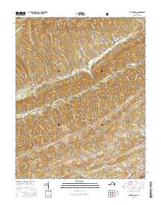
2016 Map of Hayters Gap
USGS Topo · Published 2016About this map
Hayters Gap serves as a critical mountain pass through the high ridges of the Jefferson National Forest, marking the boundary where Russell Co meets Washington Co. This region is defined by the steep slopes of Rich Mountain and Brumley Ridge, with drainage flowing into the North Fork Holston River. Settlement patterns follow the winding path of Rich Valley Road, where local history is anchored by rural communities like Shortsville, Glenford, and Lindell. The landscape is dotted with legacies of early industry and family heritage, seen in landmarks such as White Mill and Giesley Mill, alongside several historic burial grounds including McCray Chapel Cem and the Thompson Cemetery. The map detail preserves the network of hollows and gaps, from Johnson Hollow to Price Gap, that have shaped transit and commerce in this corner of the Clinch Mountain range.
Find a feature on this map
102 named features on this map. Tap any name to fly to it.
Don’t see what you’re looking for? This feature index may not catch every label — zoom into the map to look around manually.
Map Details
Editions of this 2016 Hayters Gap Map
This is the sole edition of this map. No revisions or reprints were ever made.
Other maps of this area

1891 · Abingdon
USGS Topo · 1:125,000

1894 · Abingdon
USGS Topo · 1:125,000

1897 · Bristol
USGS Topo · 1:125,000

1902 · Bristol
USGS Topo · 1:125,000

1909 · Abingdon
USGS Topo · 1:96,000

1911 · Abingdon
USGS Topo · 1:125,000

1918 · Carterton
USGS Topo · 1:62,500
1934 · Lebanon
USGS Topo · 1:24,000

1934 · Brumley
USGS Topo · 1:24,000

1934 · Wyndale
USGS Topo · 1:24,000