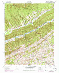
1938 Map of Hayters Gap
USGS Topo · Published 1978About this map
Clinch Mountain and Poor Mountain dominate the northern landscape of this Southwest Virginia survey, framing the high-altitude settlement of Hayters Gap. This 1938 field study, updated with late-1960s and 1970s woodland revisions, reveals a rugged agrarian economy centered around the North Fork Holston River and the rich valleys of Wolf Creek. The map provides significant genealogical value, documenting numerous family landmarks such as Thompson Cem, Jamison Cem, and Wolf Cem. Local industry and social hubs are anchored by White Mill, Greeley Mill, and a network of country churches including Wesley Chapel and Bethany Ch. A notable historic transportation artery, the Salt Works Road, winds through the southern terrain near Shortsville, while the Norfolk and Western railway corridor traces the edge of Little Mountain at Duncanville.
Find a feature on this map
68 named features on this map. Tap any name to fly to it.
Don’t see what you’re looking for? This feature index may not catch every label — zoom into the map to look around manually.
Map Details
Editions of this 1938 Hayters Gap Map
Other maps of this area

1891 · Abingdon
USGS Topo · 1:125,000

1894 · Abingdon
USGS Topo · 1:125,000

1897 · Bristol
USGS Topo · 1:125,000

1902 · Bristol
USGS Topo · 1:125,000

1909 · Abingdon
USGS Topo · 1:96,000

1911 · Abingdon
USGS Topo · 1:125,000

1918 · Carterton
USGS Topo · 1:62,500
1934 · Lebanon
USGS Topo · 1:24,000

1934 · Brumley
USGS Topo · 1:24,000

1934 · Wyndale
USGS Topo · 1:24,000