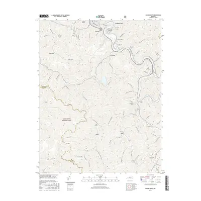
2016 Map of Hazard South
USGS Topo · Published 2016About this map
Hazard and its surrounding coal-country communities anchor this 2016 study of Perry County’s steep valley terrain. The map follows the North Fork Kentucky River through a series of industrial and residential nodes, from Woodland Park and Lothair in the north down toward Viper in the south. The landscape is defined by the winding paths of the Daniel Boone National Forest and a complex network of hollows, including Stillhouse Hollow and Jack Lot Hollow, which have historically dictated the placement of railroads and roads.
Find a feature on this map
88 named features on this map. Tap any name to fly to it.
Don’t see what you’re looking for? This feature index may not catch every label — zoom into the map to look around manually.
Map Details
Editions of this 2016 Hazard South Map
This is the sole edition of this map. No revisions or reprints were ever made.
Other maps of this area

1891 · Hazard
USGS Topo · 1:125,000

1913 · Buckhorn
USGS Topo · 1:62,500

1914 · Troublesome
USGS Topo · 1:62,500

1916 · Cornettsville
USGS Topo · 1:62,500

1916 · Hyden
USGS Topo · 1:48,000

1919 · Hyden
USGS Topo · 1:62,500

1954 · Krypton
USGS Topo · 1:24,000
1954 · Hyden East
USGS Topo · 1:24,000
1954 · Tilford
USGS Topo · 1:24,000
1954 · Vicco
USGS Topo · 1:24,000