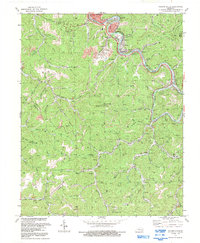
1992 Map of Hazard South
USGS Topo · Published 1992About this map
The North Fork Kentucky River defines the industrial and residential heart of this region, winding past Hazard and the concentrated mining and rail communities of Lothair, Christopher, and Diablock. The landscape is a complex network of narrow hollows and steep ridges, where coal production is evidenced by numerous mines, strip mines, and conveyors that feed into the L & N RR. This 1990s revision captures the area's deep-rooted energy economy alongside established social centers like Beech Creek Ch and the Caudill Cem. Beyond the river corridor, the map details isolated settlements such as Viper and Jeff, where terrain and water governed the pace of growth. Numerous gas wells dot the remote forks of Maceys Creek and Polls Creek, illustrating the continued extraction of natural resources throughout the Perry and Leslie county borderlands.
Find a feature on this map
84 named features on this map. Tap any name to fly to it.
Don’t see what you’re looking for? This feature index may not catch every label — zoom into the map to look around manually.
Map Details
Editions of this 1992 Hazard South Map
This is the sole edition of this map. No revisions or reprints were ever made.
Other maps of this area

1891 · Hazard
USGS Topo · 1:125,000

1913 · Buckhorn
USGS Topo · 1:62,500

1914 · Troublesome
USGS Topo · 1:62,500

1916 · Cornettsville
USGS Topo · 1:62,500

1916 · Hyden
USGS Topo · 1:48,000

1919 · Hyden
USGS Topo · 1:62,500

1954 · Krypton
USGS Topo · 1:24,000
1954 · Hyden East
USGS Topo · 1:24,000
1954 · Tilford
USGS Topo · 1:24,000
1954 · Vicco
USGS Topo · 1:24,000