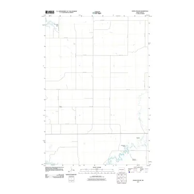
2011 Map of Hazelton SW
USGS Topo · Published 2011About this map
Horsehead Valley dominates the southeastern portion of this 2011 survey, where the winding path of Beaver Creek and its tributary Sand Creek cut through the North Dakota plains. The landscape is defined by the rigid grid of the Public Land Survey System, with roads like Main Ave and 72nd St SW marking section lines across the prairie. This area of Emmons County reflects a sparse, agricultural settlement pattern where legacy landmarks often take the form of small family or community sites. Genealogists will find the Baptist Cemetery and Winchester Cemetery positioned as solitary landmarks along the section-line roads. Infrastructure is minimal, consisting of the Reinhold Klaudt Dam on the lower reaches of the valley and the Frank Lawler Private Airport in the northwest corner, illustrating the reliance on private aviation and water management in this rural corridor north of Kenel Flats.
Find a feature on this map
25 named features on this map. Tap any name to fly to it.
Don’t see what you’re looking for? This feature index may not catch every label — zoom into the map to look around manually.
Map Details
Editions of this 2011 Hazelton SW Map
This is the sole edition of this map. No revisions or reprints were ever made.
Other maps of this area

1954 · Bismarck
USGS Topo · 1:250,000

1958 · Bismarck
USGS Topo · 1:250,000

1968 · Cannon Ball
USGS Topo · 1:24,000

1968 · Cannon Ball SE
USGS Topo · 1:24,000

1968 · Fort Yates NE
USGS Topo · 1:24,000

1971 · Grassna NW
USGS Topo · 1:24,000

1971 · Hazelton
USGS Topo · 1:24,000

1971 · Hazelton SW
USGS Topo · 1:24,000

1971 · Grassna NE
USGS Topo · 1:24,000
1971 · Hazelton NW
USGS Topo · 1:24,000